SonarWiz Bathymetry
Categories: Hydrography, Precision Survey Instrumentation, Survey Software
Description
Seafloor Mapping: Easier, Faster, Smarter
FLEXIBLE, EASY-TO-USE BATHYMETRY AND IMAGE PROCESSING TAILORED FOR GEOPHYSICAL EXPLORATION AND ANALYSIS
- Intuitive workflow saves time and reduces training costs
- Impressive image processing results for most sonars
- Comprehensive calibration, QA/QC and data export utilities
- Integrates with Sidescan and Subbottom modules for multisensor projects
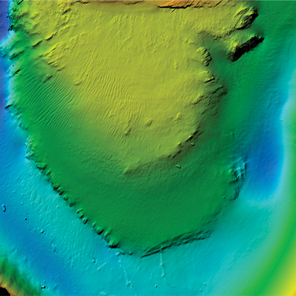
BATHYMETRY
SonarWiz Bathymetry contains all the tools you need to calibrate, edit, QC and render your bathymetric data, including support for AUV surveys with post-process navigation and attitude injection tools. SonarWiz has special support for geophysical and exploratory surveying offering 6 different gridding algorithms, volumetric and difference calculators, cross-check reports, vector contouring and more. Export raw and processed data to more than 20 supported GIS and CAD formats.
IMAGE PROCESSING, TARGETING
SonarWiz processes the acoustic backscatter simultaneously with the bathymetric soundings. This means that you can switch between rendering bathymetry or acoustic backscatter on the fly in any of the editors or displays. SonarWiz statistical normalization algorithms optimized your imagery for habitat classification and mosaic generation without degrading the image resolution. MBES Targets can be picked and cataloged using the same powerful contact utilities available for sidescan.
VISUALIZATION
SonarWiz contains interactive 3D visualization tools where bathymetry and acoustic backscatter can be easily combined with sidescan, subbottom prole (SBP) and magnetometer data to make impressive visualizations of your survey area.